RM Springfield Development Plan and Municipal Councils Bylaw
The RM Springfield Development Plan is defined as the most important Municipal By-Law. It provides governance and provincially approved long range plans that assist development and manages change throughout the Municipality.
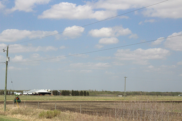
The RM has failed the ratepayers of Springfield by issuing a permit to Berger (an industrial manufacturer) without public hearings and ignoring their municipal bylaws. Springfields Council has allowed Berger to build their Peat Moss and Mixing Plant on Agricultural Lands, adjacent to Rural Residential Homes and Properties.
We have selected key points taken directly from the Springfield Development Plan, which clearly shows councils decision to allow a manufacturing plant to be built on agriculturally zoned property, goes against their governing bylaw. These points are featured below. You can also download the full Development Plans by selecting this link Municipality of Springfield Development Plan April 2021.
Key Points from Springfields Development Plan
1.1 PURPOSE OF THE DEVELOPMENT PLAN
The Rural Municipality (RM) of Springfield Development Plan (Development Plan) is a long-range plan that helps direct development and manage change in the municipality. The Development Plan sets out objectives and policies that direct development and provides standards in the context of the goals of the communities. The Planning Act outlines the purpose of a Development Plan, as follows:
1) To set out plans and policies of the municipality respecting its purposes and its physical, social, environmental and economic objectives; 2) Through maps and statements of objectives, direct sustainable land use and development in the municipality; 3) Set out measures for implementing the plan; 4) To include a livestock operation policy that provides direction to the zoning by-law dealing with livestock operations; and 5) Include such other matters as Council considers advisable.
The decisions of Council related to land use and development will be based on the goals, objectives and policies of the Development Plan. The Development Plan will also provide guidance and direction to both the public and private sectors with respect to future development of land and will ensure the timing of such development coincides with the appropriate provision of public services. The Development Plan will undergo periodic reviews, providing Council and the public with an opportunity to adjust policies, as necessary. In the future, policies may need to be amended in order to more accurately reflect new conditions or unanticipated changes to local conditions and values.
1.2 Legal Authority
The Planning Act provides the authority for the preparation and adoption of a Development Plan by the RM of Springfield, which is adopted by By-law. A Development Plan provides policies to guide development in the municipality that reflect its physical, social, environmental and economic objectives, in accordance with the provisions of The Planning Act. It includes land use maps to direct sustainable land use and development. The Development Plan must be generally consistent with the Provincial Land Use Policies (a regulation under The Planning Act), which reflect the provincial interest in land use planning. Once the Development Plan is adopted, it replaces the Provincial Land Use Policies and guides the land use decision making within the municipality. Any amendments to the Development Plan, however, are subject to the provisions of The Planning Act, the Provincial Planning Regulation and the Provincial Land Use Policies.
The following points are taken from the development plan. They clearly show how council and their planning department failed to follow their own guidelines and bylaws when reviewing the permitting applications submitted by Berger.
3.2 General Policies
3.2.4, c. Local and regional impacts with respect to traffic volumes, movement, and patterns, as well as pedestrian safety;
3.2.5 c.; Protecting and strengthening the agricultural industry where appropriate.
3.2.6 a.; That the proposed land use (s) will be developed in such a manner that will eliminate or minimize conflicts with adjacent land uses;
3.2.6 b.; That consideration has been given to the current supply and projects demand for the type of development being proposed;
3.4 Environment
3.4 Environment states in 3.4.4; To ensure that all new developments are compatible with existing land uses and that the development potential of the land does not exceed the lands capability to support such activities and/or threaten the ecological integrity and/or sustainability of the subject land.
3.5 Groundwater Protection point 3.5.3; Development or activities that could cause an impact on groundwater may not be allowed unless:
a. It can be proven by adequate engineering or hydro-geological investigation that the proposed activity will not cause pollution of the groundwater supply;
4. Rural
Three distinct settlement patterns have developed in the rural portions of the RM of Springfield influenced by factors such as soils, vegetation and topography, transportation networks, proximity to urban areas and other sensitive lands. These areas have been designated as Agricultural Preserve Area, Rural and Agricultural Area, and Mixed Rural and Agricultural Area. Land designated Agricultural Preserve Area encompasses prime agricultural land with large farm units and land holdings. Some areas of lower quality land, or small land holdings have been included in this designation to ensure future agricultural expansion options and to prevent the establishment of land uses not compatible with agriculture. With the exception of areas east of Anola, there is a very small percentage of wooded lands, most of which are associated with farmsteads. A number of rural residential lots have already been created within the prime agricultural areas which, while not seriously restricting commercial grain production, are of sufficient numbers to limit growth potential of the livestock sector.
4.1 AGRICULTURAL PRESERVE AREA AGRICULTURAL PRESERVE AREA OBJECTIVES
4.1.1 To promote the use of prime agricultural land and viable lower class land (where agriculture is the dominant land use) by allowing for a full range of agricultural activities and livestock operations.
4.1.2 To protect prime agricultural land and viable lower class land (where agriculture is the dominant land use) from unnecessary land fragmentation and encroachment of incompatible land uses.
4.1.3 To encourage the sustainable growth and development of the agricultural industry.
4.1.4 To ensure proposed developments do not negatively impact agriculture, the environment or adjacent uses.
4.1.6 c.; Agri-commercial or agri-industrial uses and small scale industrial, business and commercial operations that are used to diversify active farming operations.
4.1.9 Certain specialized agricultural activities such as nurseries, horticultural, and apiaries may be allowed on smaller parcels provided they are compatible with the surrounding agricultural activities and do not generate significant levels of traffic.
4.1.10 Agri-commercial or agri-industrial uses and small scale industrial, business and commercial operations that are used to diversify active farming operations may be allowed in the Agricultural Preserve Area, subject to requirements outlined in the zoning by-law.
4.1.11
a. The use shall not conflict with agriculture and, wherever possible, locate on lower class farmland;
b. The size of the site is appropriate to meet the needs of the use, without being wasteful of agricultural land;
4.2 Rural and Agricultural Area
4.2.5 To ensure proposed developments do not negatively impact the environment or adjacent uses.
Rural and Agricultural Area Policies
4.2.6 Lands designated Rural and Agricultural Area will be retained for large lot residential and hobby/part- time farming uses. Uses that are not compatible with existing and intended land uses will not be allowed.
4.2.7 d.; d. Small scale agri-commercial and agri-industrial operations;
4.2.10 Council shall consider the following criteria when considering proposed developments:
a. Development should not conflict with the rural use of the area and, wherever possible, locate on lower class farmland;
b. The impact of the proposed development on the existing character of the area;
9.4 Industrial Policies
9.4.9 Unless approved by the appropriate provincial government agency, businesses that are dependent upon an abundant water supply which may affect the potable water supply shall not be allowed to locate in rural un- serviced industrial areas.
12.2 Zoning By-Law
The goals, objectives and policies contained herein are generally implemented through the zoning by-law. Following adoption of the Development Plan, the municipality is required to review their zoning by-law which will set out specific requirements for land use and development. The zoning by-laws identifies zoning districts for certain types of uses. Permitted and conditional uses and development standards are prescribed for each zone. Zoning by-laws must generally conform to a Development Plan. The objectives and policies in the Development Plan provide guidance when preparing or amending the zoning by-law.
Link to the development plan directly from the RM of Springfield: RM of Springfield Downloadable Development Plan